The family tree.
Heaven and Earth has two parts: a sky map and a world map. As clock dials they have mostly been implemented separately, in centuries-long traditions that both originate with the astrolabe.
Despite being at the stem of the family tree, the astrolabe design is within two changes of ours. It arguably has both layers, just with the local horizon instead of a map as the ground layer. Swap the horizon for a north pole-centered map, and attach the hour hand to the Earth rotating counterclockwise on its axis rather than to the Sun moving clockwise across the sky, and we have the Heaven and Earth design almost to a tee.
The second of those changes would not come easily, perhaps because both the sundial and astrolabe had cemented the convention of attaching the hour hand to the Sun. Yet this is the crucial change: only when the hours and a polar map move relative to each other can one dial tell the time everywhere at once. The winding path to get there, with multiple ways of achieving the same thing, becomes an important part of our story. But first, we need to understand the astrolabe better.
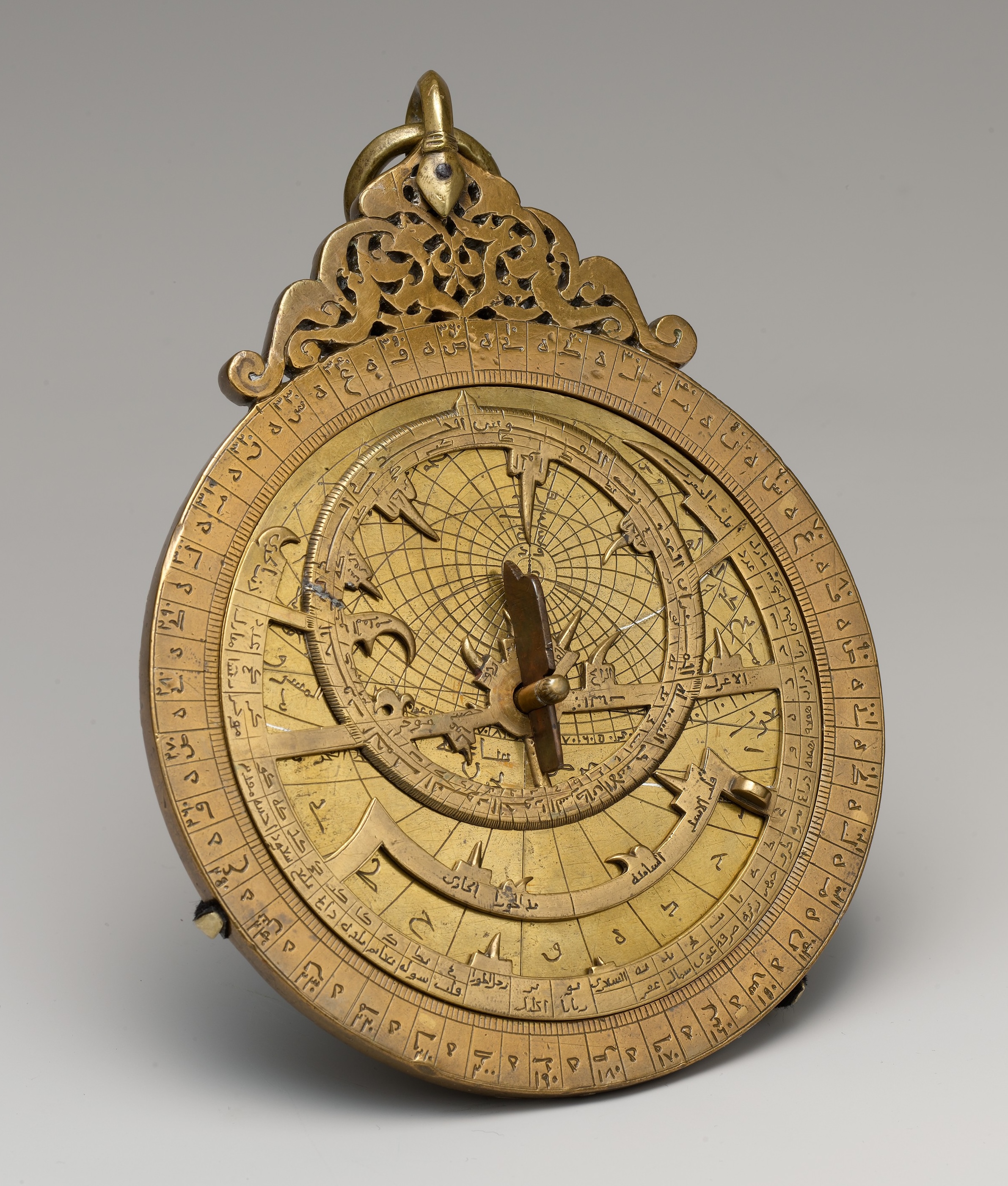
The astrolabe was a hand-held device with which one could determine the time of day using the Sun or stars. It was not a clock, but an instrument to read the time directly from the sky. The geometry is Greek – the stereographic projection is traditionally attributed to Hipparchus, around the 2nd century BCE, though the earliest surviving description of it is Ptolemy’s Planisphere, some three centuries later[1] – but the instrument’s precision and variety are largely the work of the Islamic world, whose craftsmen added prayer-time and qibla functions and a latitude-independent “universal” astrolabe. This interactive digital astrolabe simulator is helpful for understanding how it works.
Astrolabes are north pole-centered, which makes it possible to rotate the star map over the tympanum, a fixed grid of the observer's sky – horizon, zenith, altitude and direction lines – drawn for a specific latitude. Here's how to interpret an astrolabe tympanum disc for 40°N:
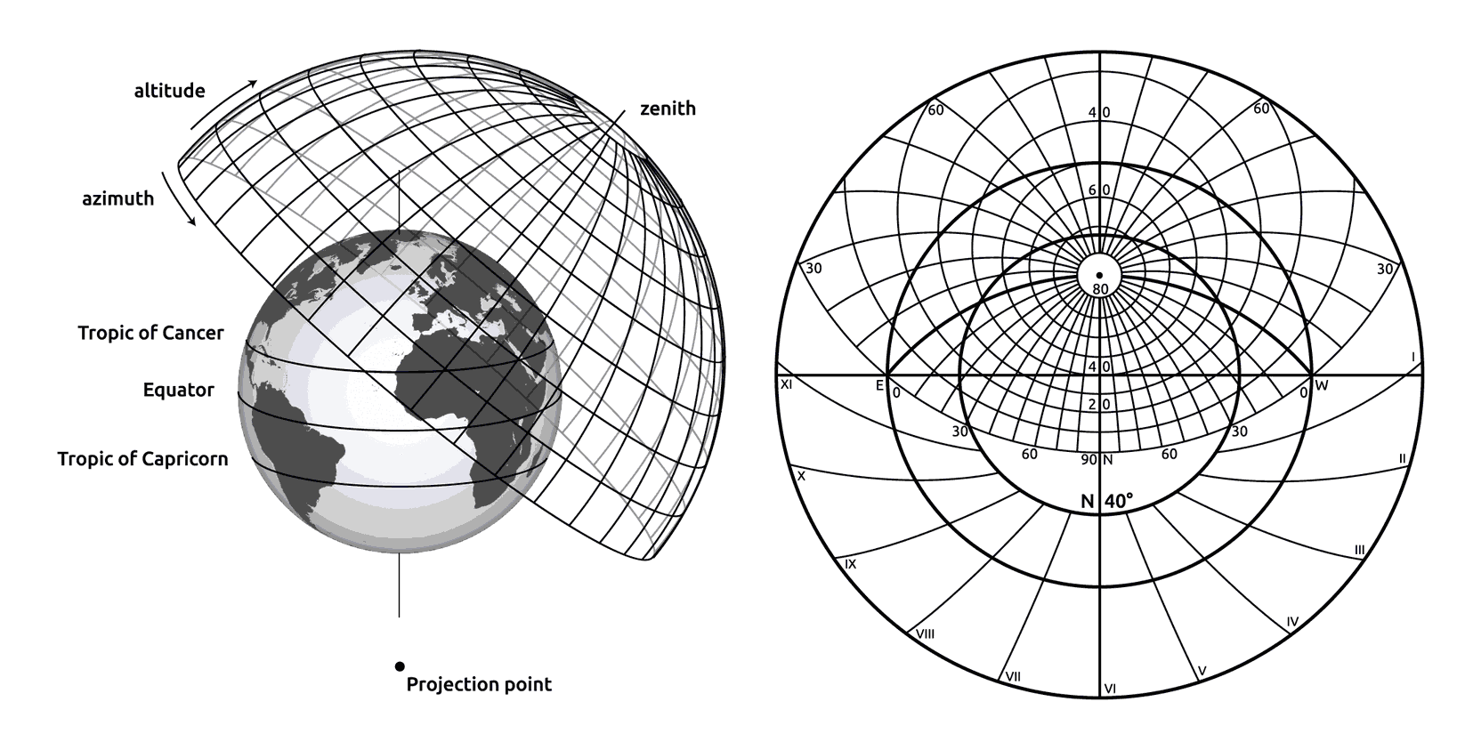
Any north pole-centered azimuthal projection would work for an astrolabe. The stereographic projection was used because it maps every circle on the sphere to a circle on the plate, so the altitude and azimuth lines of the tympanum could be constructed exactly with compass and dividers. Under an alternative projection, like the equal-area one used by Heaven and Earth, they'd be curves plotted point by point, which would be a huge amount of work before computers.
The disadvantage of the stereographic projection is that it can't show the whole sphere – the pole opposite the one it's centered on is thrown out to infinity. Astrolabe makers cut the plate off at the Tropic of Capricorn, which cost them little: the Sun is never south of it, so timekeeping was untouched, and the deep-southern sky was of no practical interest at northern latitudes.
Handheld astrolabes stayed in use for a remarkably long time – from late antiquity well into the 18th century, and in parts of the Islamic world into the 19th. Like sundials, they were only fully retired once reliable mechanical clocks were common. But early on in that transition, attempts were made to mechanize the astrolabe, making it into a sky-representing clock rather than an instrument to read time from the sky.
Mechanized astrolabes
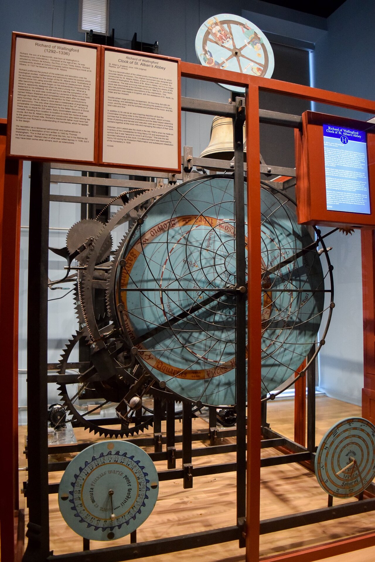
Put a clockwork behind an astrolabe dial and the sky itself becomes the clock’s face. The first known builder of a mechanized astrolabe was Richard of Wallingford, abbot of St Albans, whose great abbey clock of around 1330 was in essence a star map rotating behind a fixed open grid of the local sky – an astrolabe with its layers swapped, wound by weights.[2] (See the history article for earlier mechanized armillary spheres, and geared but not driven astrolabes.)
The idea of astronomical clocks was pursued with real enthusiasm in Northern Europe, where they became a bit of a fad between 1330 and 1600. The Stralsund clock of 1394, the Prague Orloj of 1410 and the wonder clock of Lund are essentially giant astrolabes wound by clockwork, tracking the Sun and Moon through a rotating zodiac over horizon lines drawn for each city’s own latitude. Many others took a simpler, common form: the Sun and Moon carried through a zodiac on a 24-hour dial, without the astrolabe’s horizon geometry. You can explore how the famous Prague clock works in this digital Orloj simulator.
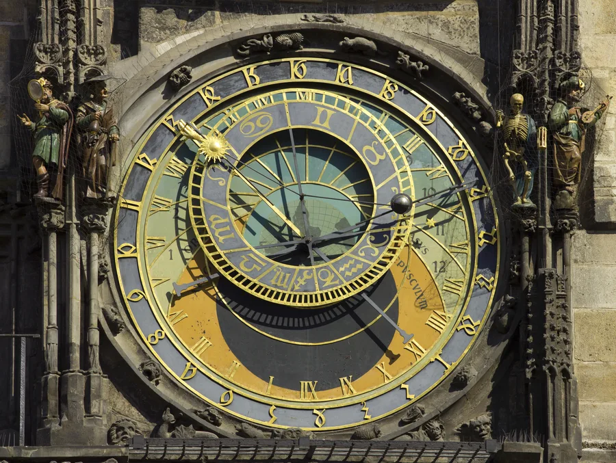
There’s variety among these clocks, as some of their makers attempted to innovate. For instance, the Prague dial is drawn in a stereographic projection from the north celestial pole, which puts the celestial south pole at the centre and the tropic of Cancer at the rim, so the summer Sun rides the largest arc – it would be mirrored relative to the standard astrolabe if it weren't for the fact that it views the celestial sphere from the inside rather than from an imagined outside, as the astrolabe does. As another example of a creative alternative design, the Münster clock of 1540–42 kept the north celestial pole at the centre but also drew the sky as seen from inside the celestial sphere – which mirrors the sky map and makes the Sun, and with it the whole clock, run counterclockwise.[3] Around 1660 its fixed background plate even received a north-polar world map, also mirrored, to agree with the star map drawn over it.
At first glance Münster can look close to the Heaven and Earth design – counterclockwise, north-pole-centred, heaven and earth together on one dial. But the resemblance is superficial. Like every other astronomical clock, Münster fixed its hour hand to the Sun, whereas in the Heaven and Earth design it is attached to the world map, which rotates once per day as the Earth spins on its axis. This is the key to making a world clock where you can tell what time it is everywhere at once. And we would get there eventually, but in the heyday of astronomical clocks in Europe, this would have been of minimal practical consequence for almost everybody, as the inventions of the telegraph and railroad were centuries away. The world was local, and naturally, so was time. It was more interesting to see how the Sun, Moon, stars and planets moved across the local sky than how the planet Earth as a whole was oriented relative to the Sun.
A terrestrial volvelle
In 1524, Petrus Apianus published Cosmographicus liber, a textbook of cosmography with working paper instruments bound into its pages – volvelles, stacks of paper discs pivoting at the centre.[4] One of them carried a north pole-centred azimuthal projection of the world map on a turning disc. The projection was anything but new – astrolabes and star maps had been drawn on it for centuries – but putting the Earth on it was fairly new at the time, no doubt because for all of history before this the majority of the planet was unmapped. The volvelle is constructed like an astrolabe with the tympanum disc (the one with the horizon and zenith) replaced by the world map. The star map is still there, in simplified form: a zodiac ring and a rule for the Sun. It would be almost exactly the Heaven and Earth design, if it weren't for the fact that it inherits the astrolabe’s convention that the hour hand is attached to the Sun rather than to a turning Earth.
The mature form of the instrument, the Speculum Cosmographicum of the later editions, shows what that means in use. Under a fixed rim of 24 hours, the map is set once and then left alone: turn it until your home town lies under the noon mark, and – the instructions are specific – fix it there with a dab of wax. The parts that move after that are the sky layers. To find where on Earth the Sun stands overhead at a given hour, you set the pointer to that hour and turn the zodiac disc until the Sun’s place for the date sits under it; the spot on the map beneath is where the Sun is at the zenith. The Earth holds still while the heavens turn above it, and the map disc moves only when the frame itself changes – re-setting the instrument to a new home meridian – not with the passing of the day.
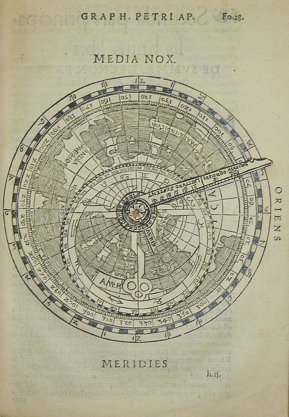
For Apianus himself, none of this was an error, because he wasn’t building a clock. The volvelle is a calculator: the book’s propositions step the reader through one question at a time – your hour in, another city’s hour out – and the operator turns the discs whichever way the procedure requires, so the direction of the numbers never matters. Only from the vantage of a world clock, an instrument nobody was yet imagining, does the handedness become a question at all. Still, the astrolabe’s family tree had put out a new branch here, toward the map-based world clock.
A static map-based world clock
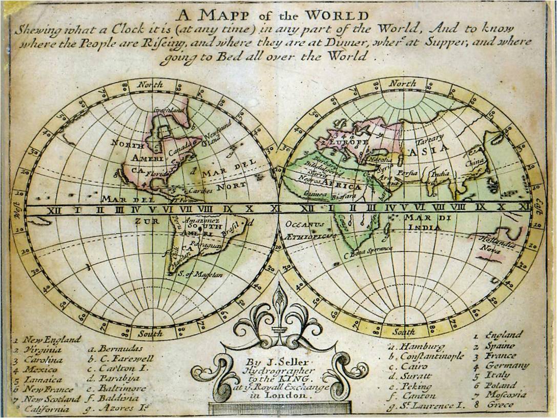
A century and a half after Apianus, around 1685, John Seller published the first map explicitly sold as a world clock – and it works: London 9, Venice 10, Constantinople 11, east reading correctly later.[5] His geometry is simply a different one: the hours run along the equator of a cylindrical map, where time and longitude march east together in a straight line and no question of handedness ever arises. It is the polar form – the map turning about its pole, as the planet does – that has to face that question, and Seller wasn’t working in it.
Landteck and Homann: the polar form, driven
In 1705, the Nuremberg clockmaker Zacharias Landteck, with the mapmaker Johann Baptist Homann, built a striking mantel clock around a north-polar world map. The map stands still; around it turns a band carrying the Sun, an illustrated sky with a dark half for night, and a ring of 24 hours – one clockwise turn per day, following the Sun’s westward march over the fixed Earth.[6] Mechanically, this is nothing the cathedral clocks hadn’t done – the clock is driven, the Earth stands still at the centre, and the Sun does the moving, just as at Münster. The new thing is what the travelling hour ring does. Its numbers run counterclockwise, so that east of noon reads later, as the geography demands (and the geography is real, not mirrored to agree with a star map); and since the numbers ride around with the Sun, every meridian of the fixed map stands against its own local hour at every moment. It is an ingenious way to get world time out of a dial without ever letting the Earth turn – but a clumsy one, because the travelling counterclockwise hours cannot double as an ordinary clock face. For that there is a second, fixed ring of clockwise hours around the outside, read against the Sun pointer – the same 24 hours twice, once for the world and once for the habit.
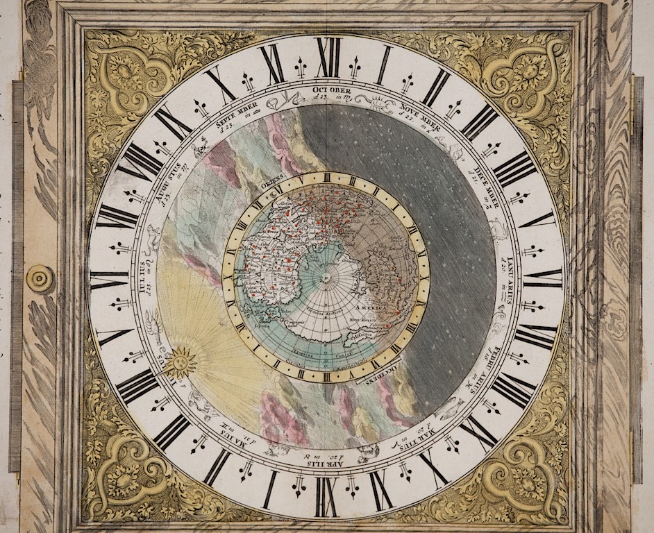
Landteck’s idea doesn’t catch on. It survives only in a diminished form – Alexandre Fortier’s planisphere clocks of the 1740s keep a driven world-time display alive in French luxury clocks, but the cities are names on rotating rings; the map itself has come off the dial.[7] The grand astronomical clocks don’t take it up either. When Strasbourg cathedral got its celebrated third clock in 1843, a north pole-centred world map did sit at the centre of the main dial – but purely as decoration: the fixed Earth of a geocentric display, Sun and Moon hands turning around it, telling no world time, the same role the Earth had played at the centre of Prague’s dial four centuries earlier.[8]
Reinvented in America
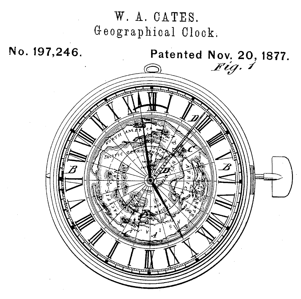
The polar world clock resurfaces in America, in patent drawings and on paper. In 1877, William A. Gates of Union, Oregon, patented a “geographical clock” whose world-map face itself revolves to illustrate the Earth’s rotation – centred on the south pole, so that the map could turn the way a clock’s hands already do.[9] Centring on the south pole lets the turning map and the familiar clock-sense agree – a reconciliation that recurs from here on.
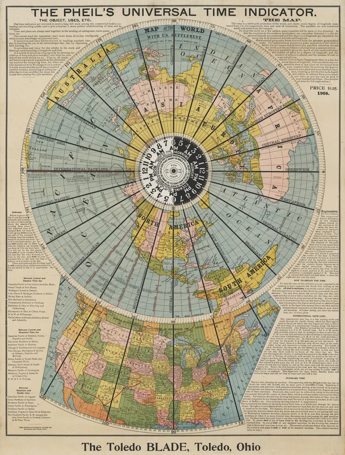
On paper, too, the idea kept being reinvented – Alexander Gleason of Buffalo published a north-polar world map with rotating time-indicator arms in 1892 (now notorious as a flat-earth artifact, but mechanically an honest world-time volvelle).[10] The most determined of these Americans was Isaac F. Pheils of Toledo, Ohio, who worked the idea in both brass and paper. He patented two clockwork-driven “geographical clocks” (granted 1900 and 1903): a north-polar world map on a stationary plate, with a 24-hour indicator revolving over it once per day.[11] A fixed map under a moving hour dial – a pattern with a big future. He also printed his Universal Time Indicator: as a still image, exactly the face Heaven and Earth uses – a north-polar world map with counterclockwise hours.[12] But set it in motion and it is his clocks again, minus the clockwork: the map is printed fast to the sheet, and the one moving part is the small hand-set hour dial at the pole. In paper and in brass alike, Pheils left the counterclockwise direction to the printed numbers and gave the motion to the hours rather than the map: the world held still, time circling over it.
Hours that move, maps that move
In 1931, the Geneva watchmaker Louis Cottier perfected the world-time mechanism his father Emmanuel had sketched in 1885: an ordinary 12-hour clock in the middle, showing local time on ordinary hands; around it, a band of 24 hour-numbers making one turn per day; and around that, a ring of city names, one for each time zone, each city always facing the number that is its current hour.[13] Patek Philippe adopted it from 1937, Vacheron Constantin and Rolex followed, and it is still the template for every worldtimer made today. The most famous Patek versions carry, at the centre of the dial, a cloisonné enamel world map centred on the North Pole.
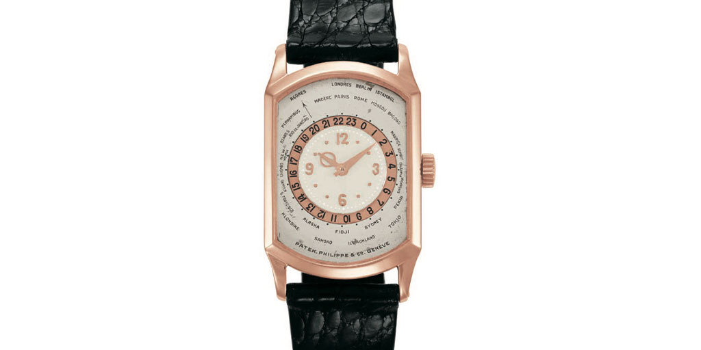
Look closely at the directions on that dial. The hour numbers on the band ascend clockwise, like any clock’s – and so, for every city’s time to keep advancing, the band itself turns counterclockwise. The city names, in turn, are laid out with east running clockwise – the mirror of their order around a north-polar map – because that is the only order that makes the reading come out right against clockwise numbers. So the world on this dial holds still, mirrored, while the hours travel over it; and on the famous versions the north-polar map at the centre – the one thing that actually turns, on the real planet – sits fixed as decoration (the same division Pheils had patented three decades earlier, and the legible choice: the cities hold still while time sweeps past them). Seen from Heaven and Earth, it is an exact mirror: the same reading, achieved by turning the hours over a stilled, mirrored world instead of turning the world under stilled hours.
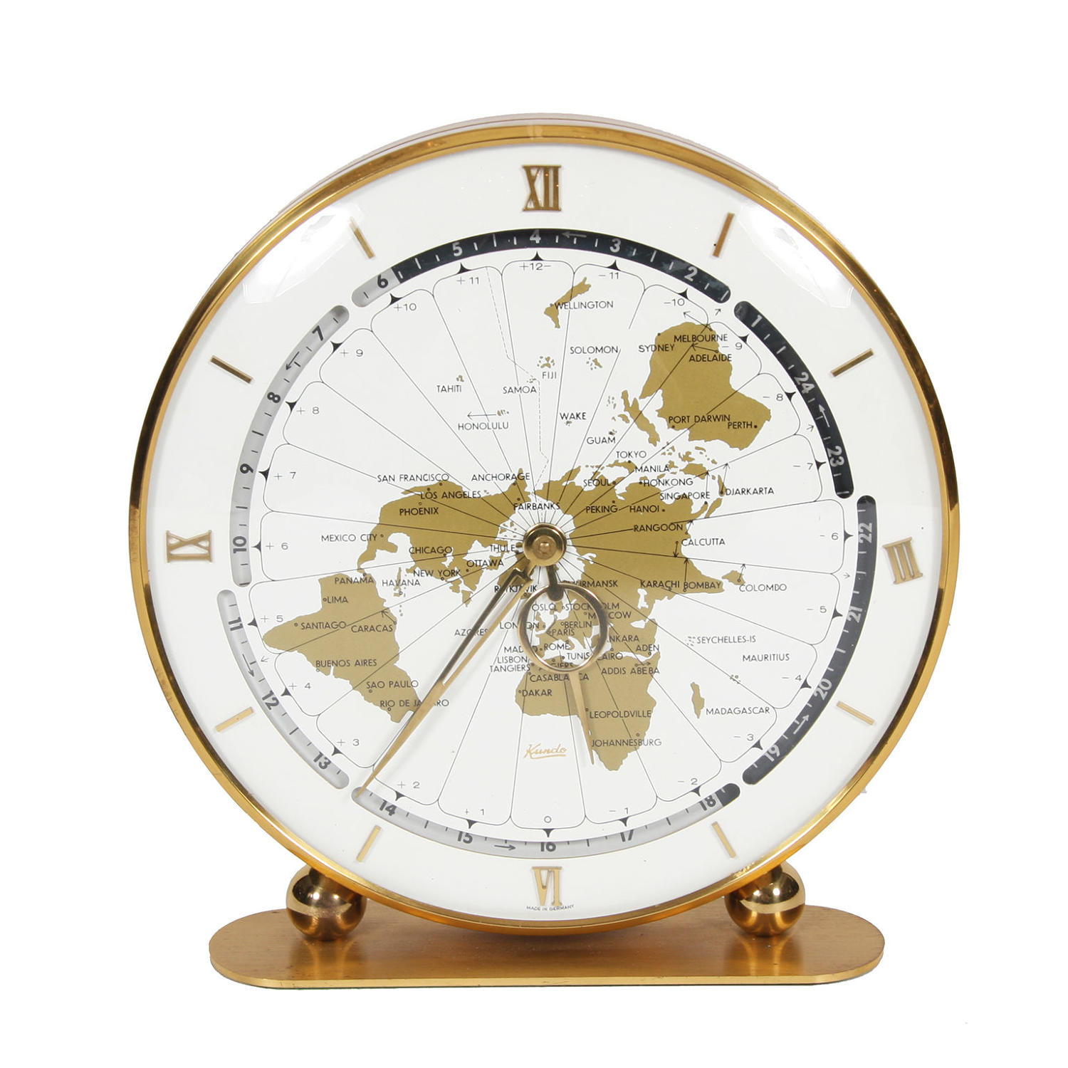
The mirror escaped the wrist, too. The 1960s Kundo world-time desk clock is Cottier’s layout moved to a desk: a north-polar map under a rotating 24-hour day/night ring – but the map is static, and a conventional clockwise clock sits on top of it: the polar map as wallpaper.[14]
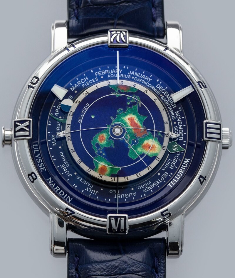
Eventually the map itself was set turning again. Ruggero Ferrari of Parma patented a clock in 1947 whose world map is the hour hand itself: a south-pole-centred map turning clockwise twice a day in the ordinary hand’s place, read against the fixed 12-hour dial – with a 24-hour ring between them turning once a day, so that map against ring still reads world time.[15] (Two turns a day: the map moves, but at the 12-hour dial’s rate, not the planet’s.) From 1965, the Geochron moves a Mercator map belt in sync with the Earth’s rotation – there the moving map really is the clock, but cylindrical, scrolling sideways, earth-only.[16]
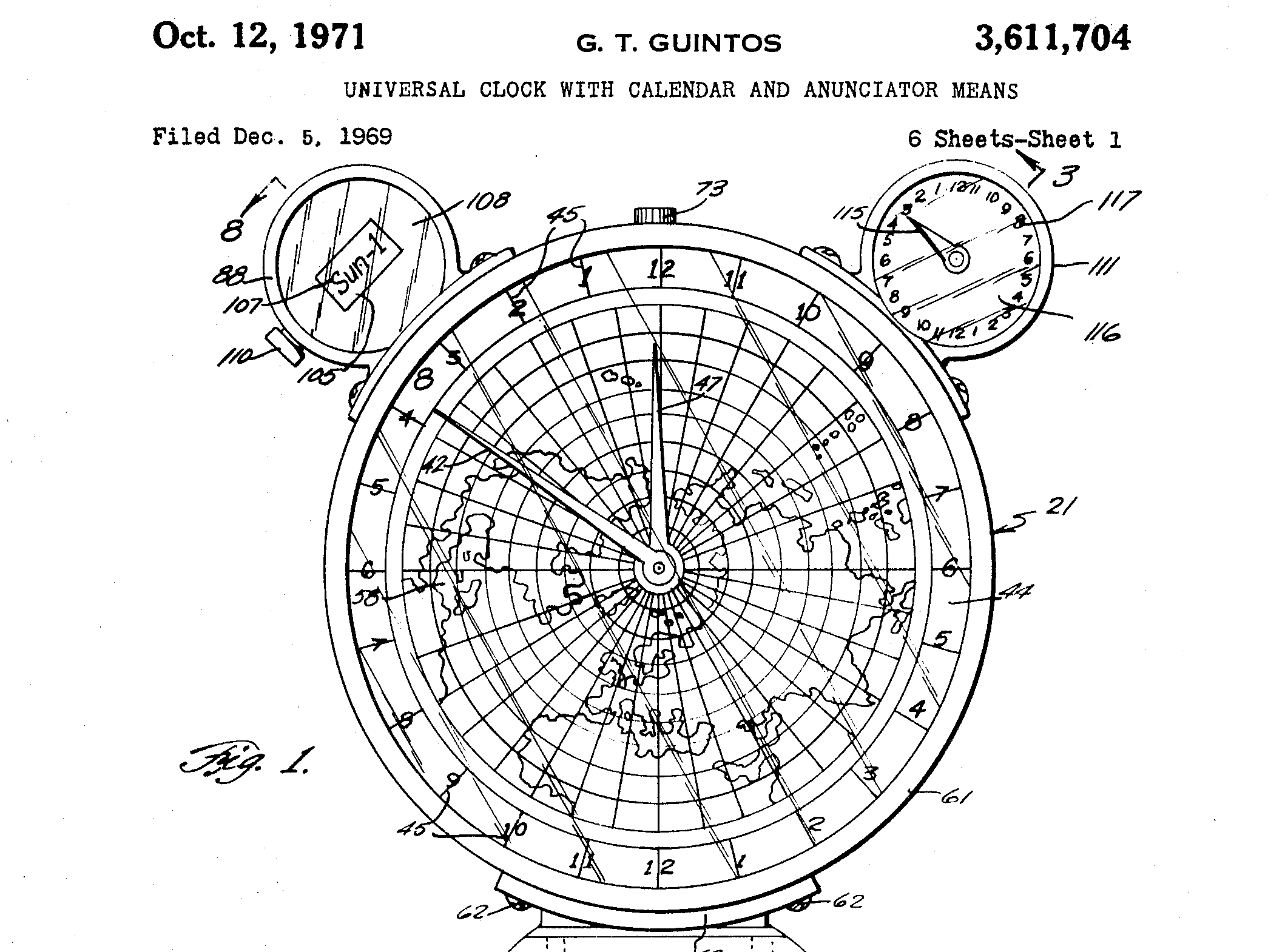
And the polar map, too, returned as the moving part. In 1969, Gorgonio T. Guintos, of Hinobaan in the Philippines, patented a “Universal Clock” turning on a pair of driven hemisphere discs – a north-polar and a south-polar world map – so that every meridian shows its own time at a glance, the northern disc revolving, in his words, “counterclockwise exactly as the earth does.”[17] This is Gates’s revolving map, ninety years on – but with the north pole at the centre, the counterclockwise turn accepted rather than designed away. Set aside its calendar and its talking alarm, and the northern face is the earth layer itself, read directly as a world clock. It would plainly work; like Gates’s, it seems never to have reached production.
The form was patented again, and at its simplest, in 1984: US 4,579,460, a “synchronous world clock” (filed 1984, granted 1986, expired 2004). The patentee was not a clockmaker but the American artist Tom Shannon, and his turning maps seem to have lived mainly as art pieces – the earth map finally the moving part, but as sculpture rather than as something to put on a nightstand.
Heaven and Earth on separate dials
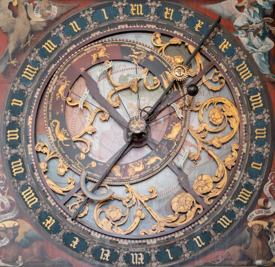
More than once, a single maker built both halves of this story – and kept them on separate dials. The grandest case is a national monument. Jens Olsen’s World Clock, completed in 1955 and on display in Copenhagen City Hall, holds twelve movements and 15,448 parts – and among them, every ingredient of Heaven and Earth.[18] Its Stjernehimlen dial is a rotating star map on the celestial pole, which even carries the precession of the pole – the clock’s slowest motion, one turn in 25,753 years. Its Synchronoscope dial is a working map-based world clock. Add the Sun’s ecliptic path, a heliocentric orrery with a zodiac, sunrise and sunset, the equation of time.
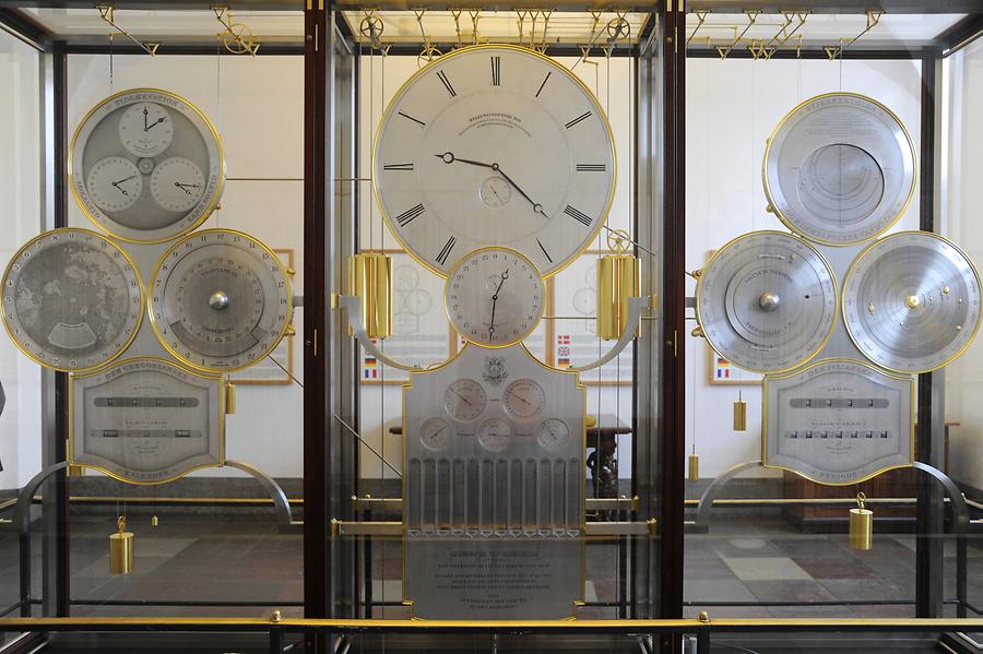
But all of it is spread across a dozen separate dials. The rotating sky and the world map never share a face; nothing is arranged to hold the Sun in place. And on the Synchronoscope, Olsen made the now-familiar choices: the map held fixed, a 24-hour ring rotating clockwise around it, and the map centred on the south pole. The legible choices, and the reverse of Heaven and Earth in both respects. The two halves of this story stood in one room in 1955, on neighbouring dials, and were never combined.
The pattern runs through Patek Philippe as well. The house’s Henry Graves Supercomplication of 1933 – for more than half a century the most complicated watch in the world – carries, among its 24 complications, a rotating celestial chart of the night sky over Central Park, as seen from its owner’s Fifth Avenue apartment: the heaven layer, in a pocket.[19] Four years later the same firm began selling Cottier’s heures universelles – the Earth’s hours, on the wrist. Sky chart and world time, one maker, never one face. (When the Supercomplication last changed hands, at Sotheby’s in 2014, it went for $24 million – then a record for any timepiece sold at auction.)
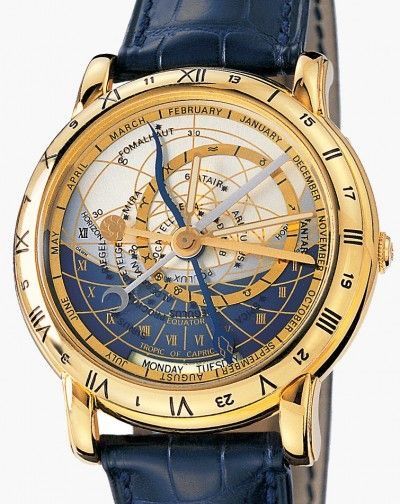
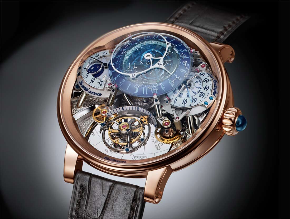
And on the wrist, the two branches met their one common craftsman again. Ulysse Nardin’s Astrolabium (1985, by Ludwig Oechslin) carried a full working astrolabe: the heaven layer, alone.[20] Seven years later Oechslin built the other half. The Tellurium Johannes Kepler (1992), the third watch of his Trilogy of Time, carries an Earth map centered on the North Pole, rotating counterclockwise once per 24 hours beneath a fixed golden sun at twelve, with a sprung wire bending across the disc to trace where day and night fall.[21] Look closely at how it is read, though, because the details are telling. The everyday time is on ordinary hour and minute hands, against numerals engraved on the case. The 24-hour ring turns with the map, 12 pinned to the Greenwich meridian, and is read against a fixed hairline in the crystal as a plain GMT display. And that arrangement breaks a simple rule: a map and a ring of hours can show the whole world’s time only if one of them turns relative to the other. Landteck’s hours travelled over a standing map; lock map and hours together, as here, and the pair carries exactly one time – the one under the hairline. The turning Earth itself, correct as its motion is, works as a day-and-night panorama – the wire really does show where the sun is rising and setting at each moment – but never as a clock: functionally, these continents are as idle as the painted ones on Strasbourg’s dial. And – remarkably – the second rate is present too: a calendar ring of months and zodiac signs circles the Earth clockwise once per year, so that the fixed sun always points at today’s date on it. That is precisely the annual contra-rotation with which Heaven and Earth pins its Sun – but the ring carries a calendar where the sky would be, and not a single star. Oechslin built the heaven layer in 1985 and the earth layer – with the sky’s rate present but empty – in 1992, and never joined them on one face.
The twist came later. The Landteck clock, long thought lost, resurfaced at auction only in 2005 – thirteen years after the Tellurium – and went to the Musée International d’Horlogerie, which Oechslin by then directed.[6] His tooth-by-tooth study of it, with its “mother of all world-time clocks” verdict, appeared in 2018: a quarter-century after locking the hours to his own turning Earth, the scholar found himself dissecting the 1705 machine that had kept them correctly apart – meeting the answer long after giving his own.
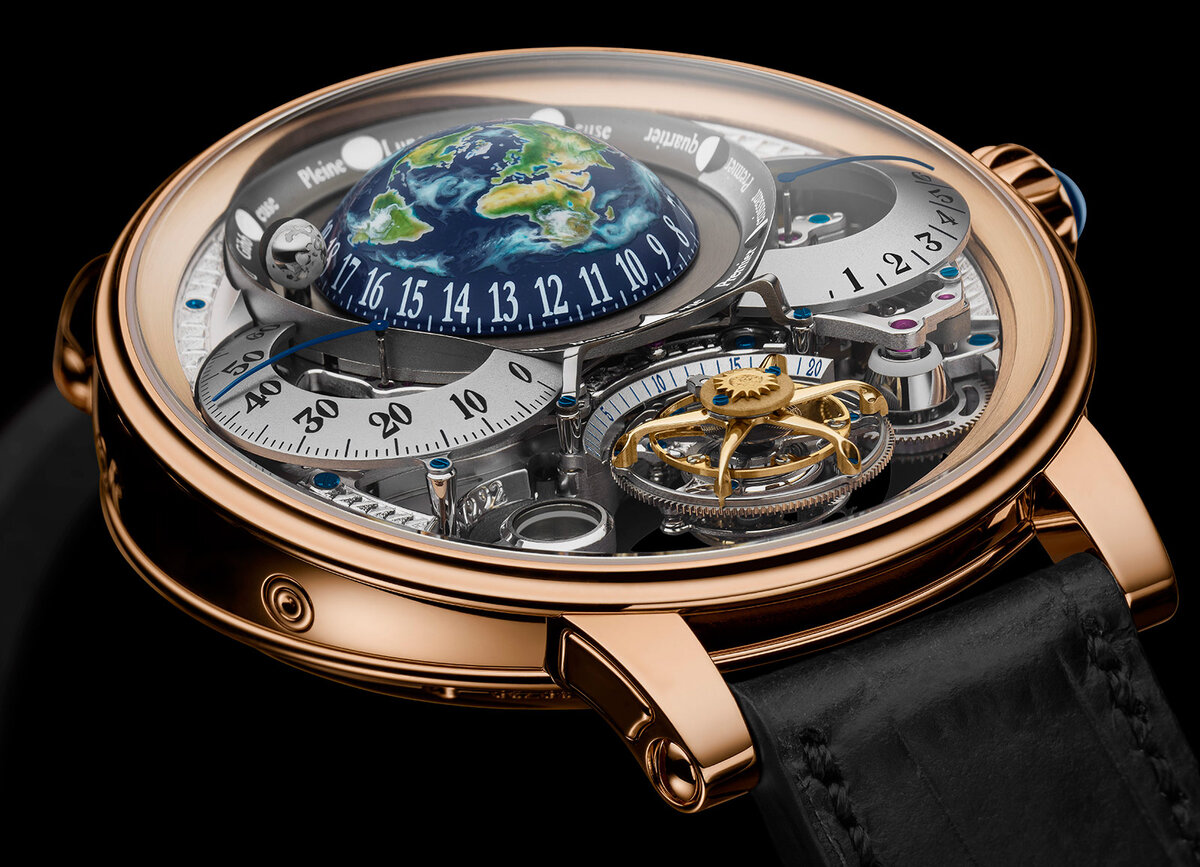
Bovet, too, has built both halves – in two watches. The Récital 20 Astérium (2017) carries the heavens: a luminous dome of night sky, the constellations engraved in translucent blue, its sidereal indications driven by an annual mechanism. The Récital 22 Grand Récital (2018) answers it with the Earth: a wristwatch tellurium with a hand-painted hemispherical Earth, seen from above the north pole, turning counterclockwise once per 24 hours as the hour display – and, across the dial, a flying tourbillon styled as the Sun.[22] Bovet will even set the globe’s orientation so that the owner’s home town faces the sun-tourbillon at midday: the sun-pinning idea, honoured as a set-up convention. The ambition has a price to match – $662,000 at an authorized dealer today – making it among the most expensive ways ever devised to watch the Earth turn. And still a tellurium has no sky – no star map, nothing for the Sun to be pinned against – and the hours ride along with the turning dome, on a ring at its base, exactly as the Tellurium’s ride its disc. The same choice, twice, a generation apart: when the Earth finally turns the right way, the hours climb aboard. Holding the Sun and keeping the stars honest at the same time – that is what an annual contra-rotation is for, and it is the one combination the record does not hold.
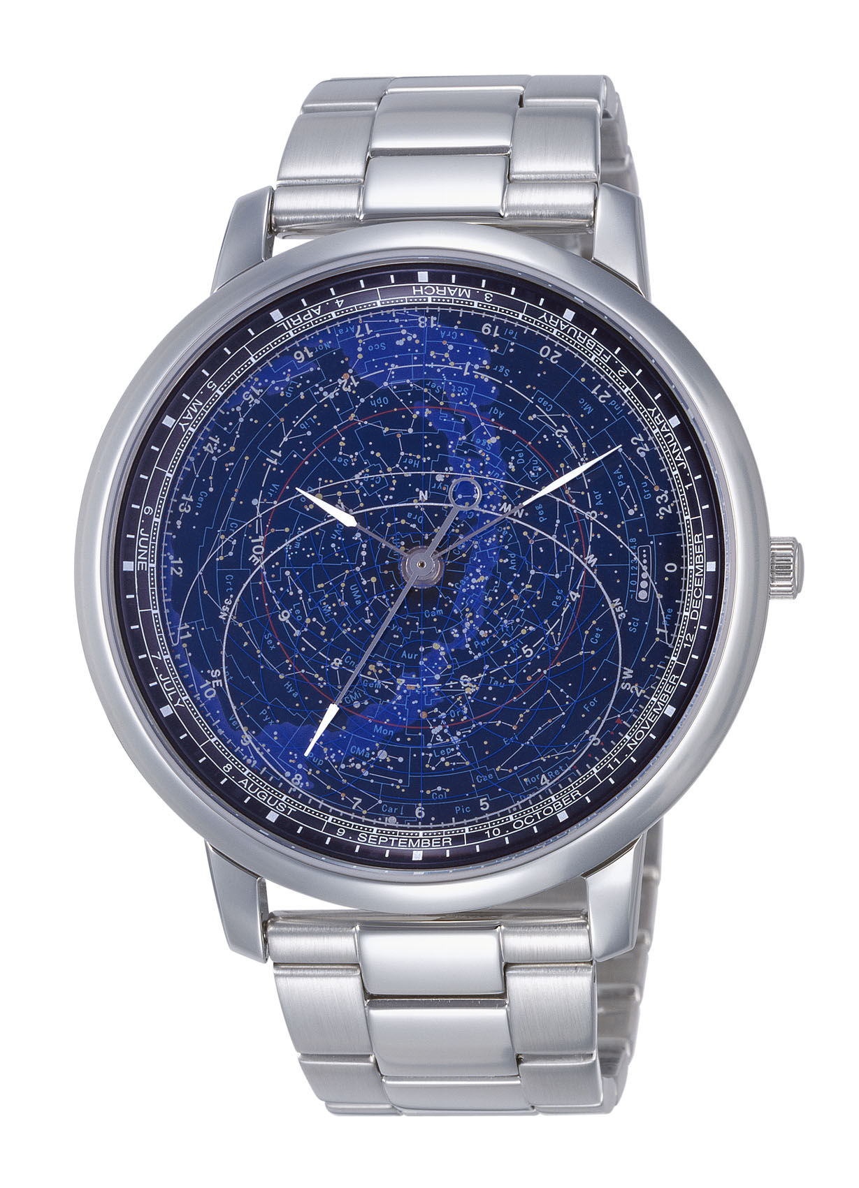
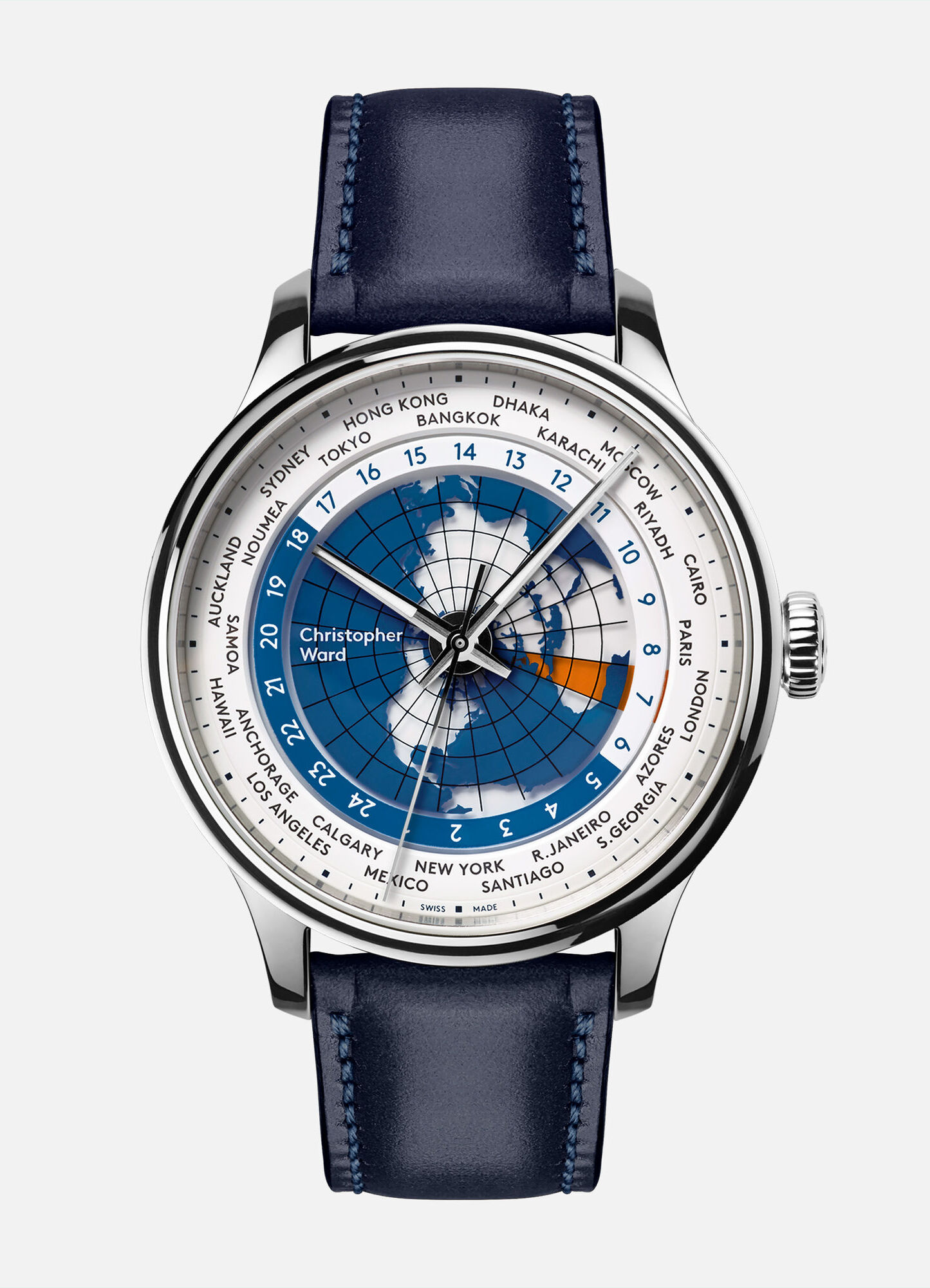
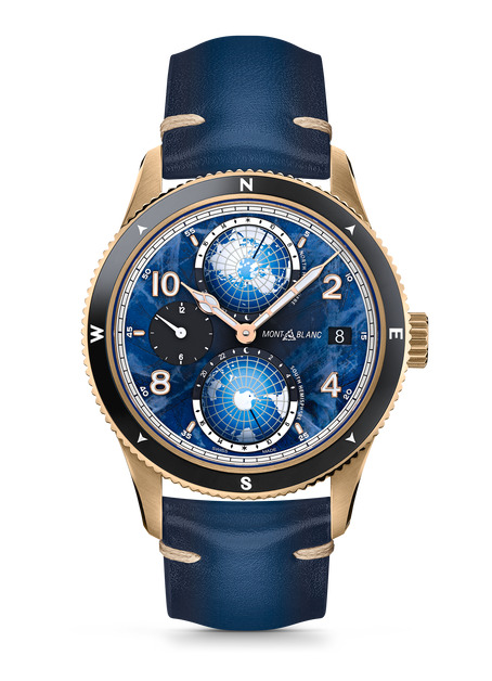
The above mentioned watches are all outrageously expensive luxury items, but both halves are within reach of ordinary buyers too. On the heaven side, Citizen’s Astrodea watches put a genuine rotating celestial chart – over a thousand stars, turning at the sidereal rate – on a quartz movement. On the earth side, Christopher Ward’s C1 Worldtimer sets a true north-polar map at the centre of its dial, Farer’s Foxe carries its world map on the rotating 24-hour disc itself, and Montblanc’s Geosphere turns two little hemisphere domes against 24-hour scales.[23] But the rule holds at every price: the heavens on one dial, the Earth on another, never one face.
So: the rotating sky map is ancient, the rotating polar world map is at least forty years old and patent-expired, a fixed sun over a turning earth exists in brass – and again and again both layers stood finished side by side: in one room in Copenhagen, in one trilogy from Oechslin, in one pair of Récitals from Bovet. No single piece is new. That is precisely why the lineage matters – what remained unbuilt was not any instrument, but the joining.
The joining
Heaven and Earth joins one branch of this family to the other. Calling it a rejoining would be wrong – the two were never one instrument. The world clock was not the astrolabe’s other half but its descendant, a different instrument built on the same anatomy. The right image is a gardener’s: a shoot from one branch, set into the other, growing into something the tree never grew on its own. And the joining does two things the family never put on one face.
It turns the map the way the planet turns. A north-polar world map rotating counterclockwise, read directly as the clock. The sky’s clockwise handedness was never wrong on the sky’s side – it is how the heavens actually sweep, and every sun-carrying dial in this story uses it correctly. A handedness question only arises when the earth itself becomes the moving part: a north-polar map must then turn counterclockwise, the way the planet turns. Apianus set the map turning but kept the sky’s numbers; Gates chose the south pole so a turning map could keep clock-sense; Landteck, Pheils, Cottier and Olsen rested the world and moved the hours instead. Heaven and Earth turns the north-polar map, counterclockwise, under hours that stand still – and reads it directly as the everyday clock.
It adds a motion neither parent had. The sky appears to turn once per sidereal day because two motions add together: the Earth’s daily spin, and its yearly orbit around the Sun. A classic astrolabe clock lumps both into one star wheel – that is what the sidereal rate is – and then needs a separate solar hand to carry the Sun around the dial. Heaven and Earth divides the labour along the physics instead: the daily spin goes to the earth map (once per day, counterclockwise), and the yearly orbit goes to the sky map (once per year, clockwise, contra-rotating). Between the two layers the sky still turns at the true sidereal rate – nothing is faked – but on screen, the yearly counter-turn cancels exactly the drift that would otherwise carry the Sun slowly around a fixed-hours dial. So the Sun keeps its station at the top – noon at the top, midnight at the bottom – even though it is genuinely moving through the sky: the Earth turns beneath it, the constellations wheel slowly behind it, and every planet sits where it really is relative to the Sun. The astrolabe never turned an Earth; the world clock never turned a sky above it. This is the first face we can find where both turn.
Strictly, what the contra-rotation pins is the mean sun – the steady, averaged sun that clock time is built on. The true Sun runs seasonally a little fast or slow of it, and rides higher or lower with the seasons, so on the dial it wanders slightly about the noon mark through the year, tracing the small figure-eight known as the analemma – the same wobble that makes sundials disagree with watches. One could be forgiven for reading the Sun on this face as simply fixed – and a clock that pinned it exactly would still be a fine design for almost every purpose. Heaven and Earth draws the true Sun anyway, as a small bonus of realism: speed up the live clock at the end of this page and you can watch it wander.
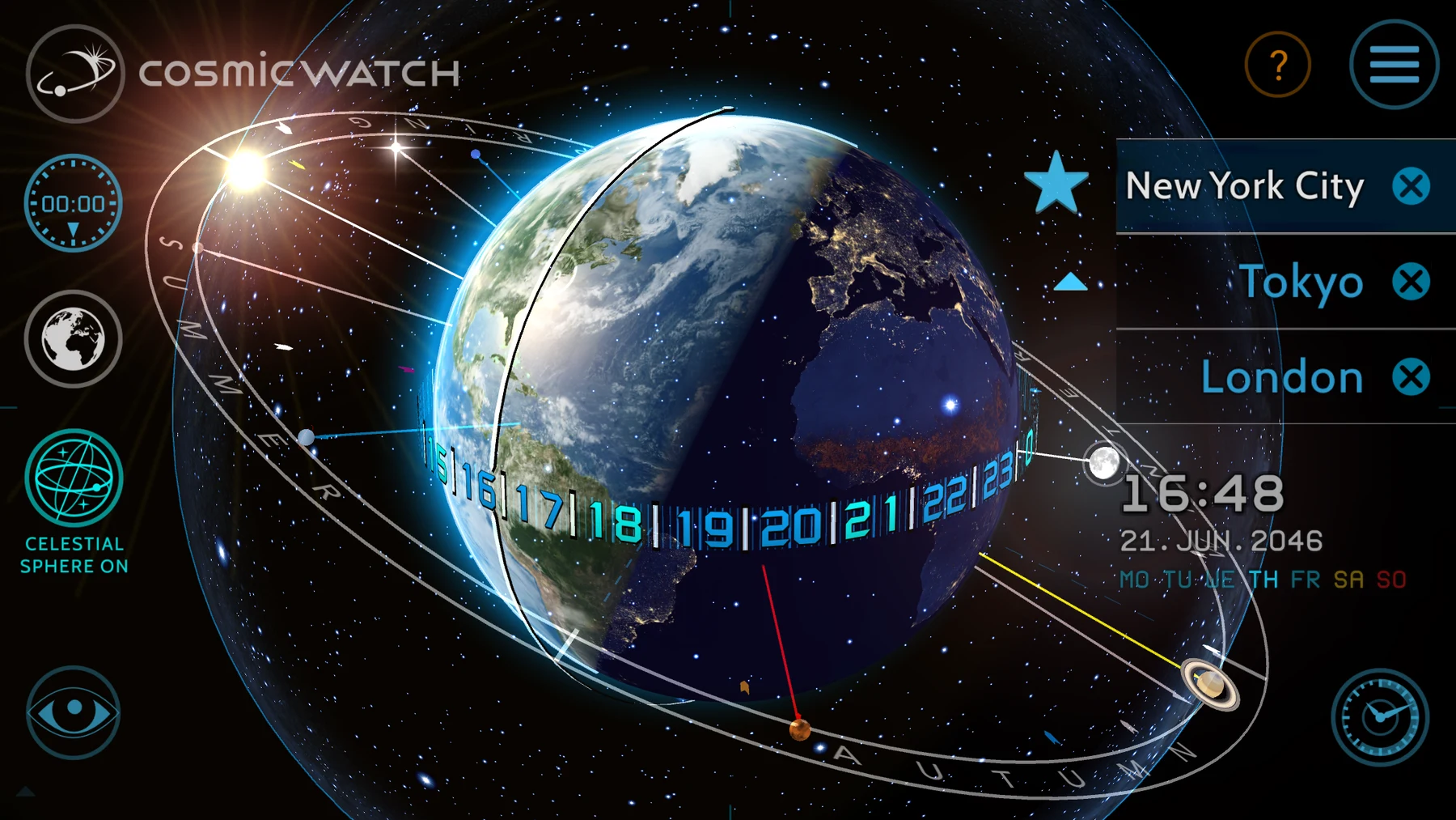
Even the digital age has its near-relative. The Cosmic Watch app (2016) – “the first astronomical clock of the digital age,” by its makers’ description – places a real-time three-dimensional Earth at the centre of a celestial sphere, with a 24-hour dial laid along the ecliptic and synchronized to the noon-time sun.[24] Heaven, earth and a sun-referenced dial in one object – and a confirmation, by contrast, of where the actual work lies. As a free-flying 3-D scene, nothing in it is projected and nothing contra-rotates; it does not read at a glance as a clock face. It is the armillary sphere reborn. Heaven and Earth is the astrolabe reborn – the same flattening that turned the celestial sphere into a readable disc two thousand years ago, applied to both spheres at once.
Every individual piece has a precedent somewhere in these two branches – that is what this page has tried to show honestly, and a systematic pass through the world-clock patent record bears it out. It also bears out the other half: every near-miss we could find lacks exactly one of the defining features. The rotating earth-map clocks – Shannon’s patent, the Tellurium, the Bovet – carry no star map. The astronomical clocks – Prague, Olsen – run their sky at the sidereal rate and never pin the Sun. The one-face earth-and-sky objects are hand-set calculators, or drive a shadow mask instead of a sky, or run a static earth under a sidereal sky. The synthesis is what we can find no precedent for: a rotating polar earth map that is the everyday clock, overlaid with a celestial map in the same projection counter-rotating once a year so the Sun keeps its place at noon. (“No precedent” is a claim about a global, centuries-deep record, and we make it carefully – but every candidate found so far misses.) A screen makes the second motion trivial to run – no gear train to cut – which is why this joining arrives now, as something you can wear for free on an ordinary smartwatch, rather than in brass three centuries ago. How the two layers work together is laid out on the concept page.
That is the mechanism; the reason it matters predates every instrument on this page. Our devices first brought us into a close, working relationship with the night sky, and then gradually replaced the sky as time’s authority altogether – severing that connection and leaving us astronomically disoriented. Heaven and Earth is one small attempt to mitigate that severing; the fuller story is told in a separate article.
Notes & references
- The stereographic projection is traditionally credited to Hipparchus, but the attribution comes only from Synesius (c. AD 400); the earliest surviving description is Ptolemy’s Planisphaerium (2nd c. AD). Astrolabe, Wikipedia.
- Richard of Wallingford’s St Albans abbey clock (c. 1330) – essentially a star map rotating behind a fixed open grid of the local sky, the earliest known Western clock with an astrolabic dial. J. D. North, God’s Clockmaker: Richard of Wallingford and the Invention of Time (2005); Richard of Wallingford, Wikipedia. On the older mechanized heavens: Su Song, Wikipedia; al-Jazari’s castle clock is described in his Book of Knowledge of Ingenious Mechanical Devices (1206).
- Münster astronomical clock, Wikipedia – a 24-hour, counterclockwise clock centred on the celestial North Pole; the world map was added c. 1660–1670, mirrored to agree with the star map.
- Petrus Apianus, Cosmographicus liber (Landshut, 1524) and later editions to 1545; the north-polar world-map volvelle is Shirley World Maps #51. Sanderus Antique Maps. The 1564 Withagius/Frisius edition, with the Speculum Cosmographicum volvelle at fol. 28, is digitized at the Internet Archive.
- John Seller, A New Systeme of Geography (London, c. 1685; later 1690 edition), plate “A Mapp of the World, shewing what a Clock it is (in any part of the World).” New York Public Library, “Round We Go: Volvelles” (2023); dating per Crouch Rare Books.
- Zacharias Landteck / Johann Baptist Homann, Geographische Universal-Zeig und Schlag-Uhr (Nuremberg, 1705). Boston Rare Maps; Geographicus. The surviving original is held by the Musée International d’Horlogerie, La Chaux-de-Fonds (acquired 2005); Ludwig Oechslin’s monograph on it (2018) calls it “die Mutter aller Weltzeituhren” – the mother of all world-time clocks. The central polar map is a fixed enamel hemisphere; the Sun pointer, day/night shade and calendar rings rotate over it. See also Wolfram Dolz in Globe Studies 51/52 (2005).
- Planisphere clock, movement by Alexandre Fortier, case attributed to Jean-Pierre Latz (Paris, c. 1745–49) – overlapping rotating plates showing the hour, months, lunar days, and the local time in various cities and parts of the world. J. Paul Getty Museum.
- The clock’s third (Schwilgué) movement, 1838–1843. On the main “temps apparent” dial the Sun and Moon hands revolve around a fixed terrestrial hemisphere at the centre, which represents the Earth (held immobile, in the geocentric sense); the north-polar world map on it does not rotate and indicates no world time. patrimoine-horloge.fr; Horloge astronomique de Strasbourg, Wikipédia.
- William A. Gates (Union, Oregon), “Improvement in Geographical Clocks”, US patent 197,246 (filed August 24, 1877; granted November 20, 1877) – a south-polar world-map face that revolves with the hour hub. The specification reads Gates; the drawing sheet’s “W. A. Cates” is a plate-lettering error. Google Patents.
- Alexander Gleason, “New Standard Map of the World” (Buffalo, NY, 1892) – a north-polar azimuthal-equidistant world map with two rotating time-indicator arms. Boston Rare Maps.
- Isaac F. Pheils, “Geographical Clock”, US patents 641,540 (filed 1898, granted 1900) and 718,579 (filed 1901, granted 1903) – a north-pole geographical projection on a stationary plate, with a clockwork-driven “universal hour hand” indicator revolving over it once per 24 hours.
- Isaac F. Pheils, The Pheil’s Universal Time Indicator (“Map of the World with U.S. Supplement”), published by the Toledo Blade, Toledo, Ohio. George Glazer Gallery; David Rumsey Map Collection. Dating, per the sheet itself: “Copyright 1901, by Isaac F. Pheils, Woodville, Ohio”, with the printing shown here priced 1905; dealer catalogues date other examples to 1906. The map is printed and fixed; the rotating element is a cardboard 24-hour day/night “revolving dial” at the North Pole – the hour circle of the 1900 patent – set by hand to local time.
- Louis Cottier’s heures universelles mechanism (Geneva, 1931; after Emmanuel Cottier’s 1885 concept), adopted by Patek Philippe from 1937 (refs 515 HU, 96 HU, 1415, 2523) – central local time, a counterclockwise-rotating 24-hour ring, and a city ring; the celebrated versions carry a fixed cloisonné north-polar world map at the centre. Collectability, “A Brief History of the World Time” (source of the ref. 515 image); Collectability, “Inside the Movement: Louis Cottier”; Oracle of Time. Cottier’s archive is held by the Musée d’art et d’histoire, Geneva.
- Kieninger & Obergfell (“Kundo”) GMT world-time table clock, 1960s. Pamono.
- Ruggero Ferrari (Parma), “Universal and Ordinary Clock”, US patent 2,615,298 (filed 1947, granted 1952) – three concentric discs: a stationary 12-hour dial, a 24-hour ring rotating clockwise once per 24 hours, and a south-pole-centred world map rotating clockwise twice per 24 hours “in the same manner as does the usual hour hand, which it replaces”; map against ring nets one relative turn per day, so the universal reading still works. Cited as prior art in US 4,502,789. Google Patents.
- The Geochron world clock, James Kilburg, 1965 – a clock-motor-driven Mercator map belt with a day/night mask. geochron.com.
- Gorgonio T. Guintos (Hinobaan, Negros Occidental, Philippines), “Universal Clock with Calendar and Annunciator Means”, US patent 3,611,704 (filed December 5, 1969; granted October 12, 1971) – a pedestal clock built on two driven, revolving hemisphere discs, a north-polar and a south-polar world map, that “accurate time is indicated at various degrees of longitude in both hemispheres.” The northern disc revolves “counterclockwise exactly as the earth does,” carrying a counterclockwise 24-hour dial, with a coordinated calendar and a base annunciator that speaks the time. Google Patents.
- Jens Olsen’s World Clock, Wikipedia – completed 1955, Copenhagen City Hall; the Synchronoscope dial is a fixed south-polar map with a rotating 24-hour ring; the Stjernehimlen dial is a rotating star map with the precession of the celestial pole (one turn in 25,753 years, the clock’s slowest gear). See also the Linda Hall Library.
- Patek Philippe, the Henry Graves Supercomplication (delivered 1933) – 24 complications, including a celestial chart of the night sky over Central Park as seen from Graves’s Fifth Avenue apartment; the most complicated watch in the world until 1989. Sold at Sotheby’s Geneva, 11 November 2014, for CHF 23.2 million (≈ US$24 million), then a record for any timepiece at auction.
- Ulysse Nardin Astrolabium Galileo Galilei (Ludwig Oechslin, 1985) – a working astrolabe wristwatch: Sun, Moon and star positions, sunrise/sunset, eclipses. ulysse-nardin.com. The heaven layer also reached the patent record as US 6,744,695, “Planisphere watch” (2004).
- Ulysse Nardin Tellurium Johannes Kepler (Ludwig Oechslin, 1992), the third watch of the Trilogy of Time – a cloisonné enamel Earth viewed from above the North Pole, rotating counterclockwise once per 24 hours, with a flexible spring tracing the day/night boundary, an orbiting moon and eclipse indicators. The reading details are from Ulysse Nardin’s own Trilogy of Time instruction manual: legal time on the hour and minute hands against the case numerals; the 24-hour division turning with the Earth disc, showing GMT under a reference line inlaid in the crystal; the ecliptic (date/month/zodiac) ring rotating clockwise, read below the fixed Sun. Also: Antiquorum lot descriptions (refs 871-99 / 889-99); Marcus Hanke, The Trilogy of Time.
- Bovet Récital 22 Grand Récital (2018; Aiguille d’Or, GPHG 2018) – a hand-painted hemispherical Earth, viewed from above the north pole, rotating counterclockwise once per 24 hours as the hour display, with a flying tourbillon styled as the Sun across the dial and a spherical moon at its true synodic period; the globe’s orientation is set per owner so their chosen location lies on the earth–sun axis at midday. Its heaven counterpart is the Récital 20 Astérium (2017): a luminous night-sky dome, constellations laser-engraved in translucent blue, with sidereal indications governed by an annual (365.25-day) mechanism. Launch prices US$469,800 (red gold) / $502,200 (platinum); the platinum version is listed at $662,000 at Mayors (July 2026). bovet.com; GPHG 2018; Quill & Pad.
- Citizen’s Astrodea / Cosmosign celestial watches (Japan; quartz, 1,109 stars, sidereal rotation, sold largely through astronomy shops): aBlogtoWatch. Christopher Ward C1 Worldtimer (northern-hemisphere polar projection, 24 cities); Farer Foxe; Montblanc Geosphere (two hemisphere domes – both are the Earth, seen from opposite poles, so their counter-rotation is not an earth–sky contra-rotation): Monochrome buying guide.
- Cosmic Watch (Celestial Dynamics, 2016) – a real-time 3-D Earth at the centre of a celestial sphere, with a 24-hour dial along the ecliptic synchronized to the noon-time sun. cosmic-watch.com.